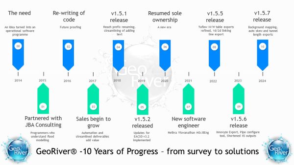
GeoRiver Latest

10 Years of progress

10 Years of progress

A lot has happened since the initial release of GeoRiver back in 2014. Our hands-on use and continual development of the software has helped it become a critical tool in our workflow. We hope to bring the benefits of GeoRiver to a larger market and look forward to seeing it continue to go from strength […]

Read More
Quote from Survey Operations Director Anthony Pritchard

Quote from Survey Operations Director Anthony Pritchard

Our surveyors are using this software every day to produce the deliverables that our clients want. Storm GeoRiver is reliable in handling river channel data and high in performance when it comes to reaching the quality and speed that is required. Our surveyors quickly found that they could trust and enjoy using the software on […]

Read More
GeoRiver export to Tuflow

GeoRiver export to Tuflow

Tuflow is next on the agenda for a direct river model export from GeoRiver. Initially the export will handle the channel profile and then a second phase of development will take structures and Conveyance Estimation System data straight into the Tuflow model. This is going to be a valuable tool to anyone setting up a […]

Read More
Initial Feedback

Initial Feedback

We have shown Storm GeoRiver to a handful of people now and they all agree that it will help improve their efficiency and save them money. Some people are warming up to the functions on offer in V1.1 and of course, if you have a licence this upgrade comes free. Some people will have been […]

Read More
About To Go Live

About To Go Live

It was three years ago when we put pen to paper and started developing a standalone piece of software that was to take river model data further towards the finished article. After hours of meetings in darkened rooms, many hours at the keyboard, and countless testing phases we are about to release version 1.0. This […]

Read More