Case Studies
Rhondda Valley Project
Overview
The Background
Between July and November 2021, Storm Geomatics undertook a survey in the Rhondda Valley for Natural Resources Wales on behalf of engineering consultancy ARUP.
Storm Geomatics delivered the data to the client in a variety of modelling formats including Flood Modeller, Tuflow and HecRas as requested. In addition, Storm provided Arup with a GeoRiver® licence and the complete GeoRiver® model from which all survey deliverables are derived.
Process
What the engineer thought
On completion of the project Storm spoke with Arup’s engineer to discover how they quantified working their model through GeoRiver and to what extent it improved their experience.
How much did you use the GeoRiver® model during your model build?
I used GeoRiver® a lot when reviewing sections – it was particularly useful for easily bringing cross-sections, photos and viewing/reviewing in order and space. It also made the initial export to FM and TUFLOW formats easy.
Which features did you find particularly helpful?
I used less of the other build tools that I think are in GeoRiver®, mainly because a lot had already been done/exported by Storm beforehand, and for some build tasks (particularly structures) we already had internal tools that were designed for internal workflows.
How much time do you think GeoRiver® saved you?
Having the data in good format ready for import into FM/TUFLOW saves days’ worth of time (admittedly Storm had already done a lot of this but did use GeoRiver®!). Having a clear method to review sections with pictures saves further time in review.
How could GeoRiver® be improved for your use?
It sounds like you have already picked up on my key points/issues around file references and implementing roughness values.
It is a good additional selling point for Storm, although I think may need further review for ensuring it works well with other surveyor’s data.
Additionally needs to ensure it continues to track development of TUFLOW/FM software, and the requirements of key clients such as EA/NRW.
Would you use it on subsequent river modelling projects?
Yes, particularly for Storm data, with continued review on other surveyors’ data.
Process
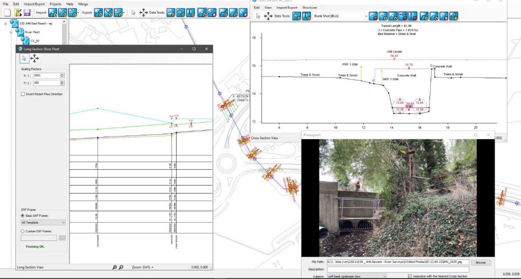
Conclusion
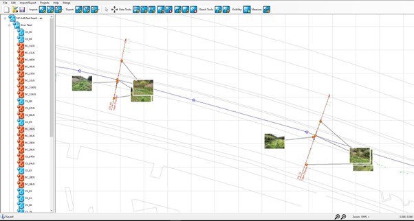
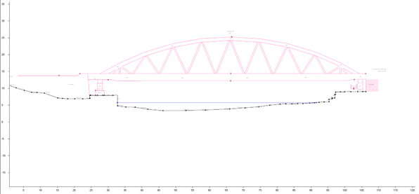
This was an ideal project for the development team to test GeoRiver’s® compatibility with engineers. By providing the engineer with the GeoRiver® model they were able to view the cross sections, long section, plan position of each observation and required photos all in one single place and easily accessible. Allowing control over how to view certain aspects of the data. For example, giving the option to view the long section at any scale required and in either direction. Within the cross-section window, the user can also view the chainage and elevation of any point with a single click.
Saving the client days’ worth of modelling time has been the major benefit from this project and simply secures GeoRiver® as the only River Modelling software with this capability.
For more information please do book a discovery call with GeoRiver® Champion Anthony Pritchard via the website link Want to Know More Please.
You can also find informative short explainer videos via the YouTube Channel. Why not check them out and you too can save day’s of modelling time!