Case Studies
Minsmere and Yox Model Survey to Assess Flood Risk
Overview
The Background
This watercourse survey was conducted on behalf of the Environment Agency through Storm’s long standing client JBA Consulting Limited during Autumn 2022. The survey involved 19 different reaches, over 350 cross sections and spanned over 34000m of watercourse. Its purpose was to enable the Environment Agency to assess flood risk to the area, identifying the potential properties and communities at risk. Multiple teams from both Storm Geomatics Head office and Southeast office were utilised to complete the survey.
Process
The Challenge
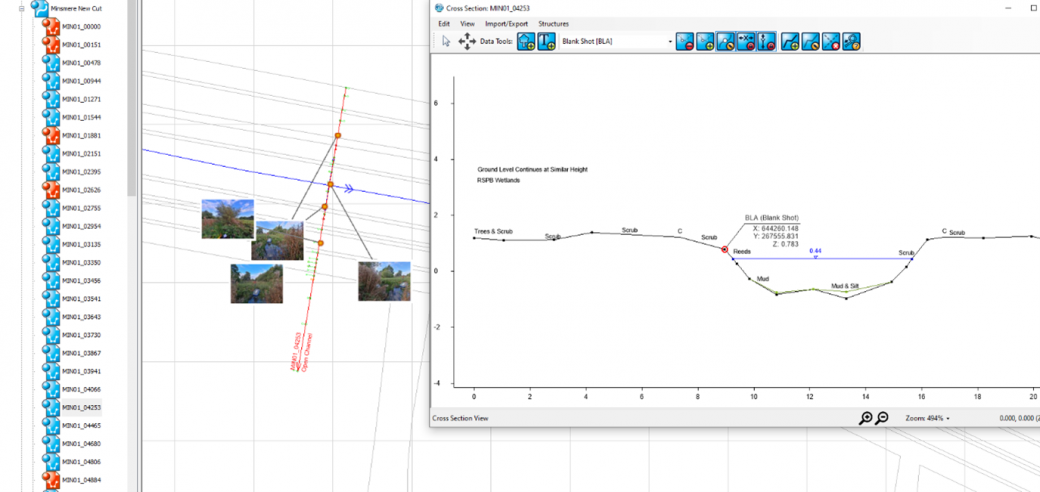
A further challenge for the team was collating the data and ensuring that progress of each watercourse was recorded so that the handover of data from one surveyor to another went smoothly. Surveyors processed the data in Trimble Business Centre, and then exported this data to .CSV files and arranged it correctly so that it could be imported into our own software, GeoRiver®. So intuitive is GeoRiver®, the task of processing cross section survey data was very efficient from the drawing of cross sections (including structures), to placing of photos with bearings and being able to export different data sets so that they can be read by the latest flood modelling software and also pass EACSD validation.
The data goes through many Quality Assurance stages making sure that the final data sent to the client is to the stated specification and bespoke to the project specification.
Process
The Results
All work was completed to the latest Environment Agency specification (V5.0) with certain elements of the deliverables being bespoke to the needs of JBA Consulting Limited. All of the cross-section data was processed using GeoRiver® and multiple sets of data were exported from here. This includes Flood Modeller, XYZ data, valid EACSD files, CAD drawings and georeferenced photographs with bearings.